
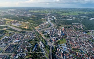
“SEBERANG” LITERALLY MEANS “the other side”, and for generations, the strait dividing Penang’s mainland from the island reinforced the separation between both jurisdictions. Larger than Singapore, and connected by rail and road to the entire peninsula, Seberang Perai was long overshadowed by what lay across the water. Today, growth and investment have transformed the mainland in ways that would have been unimaginable even a generation ago. The Penang2030 vision formalises what has already been becoming apparent: that balanced development between island and mainland is no longer optional, but essential to the state’s future.
A NEW VIEW OF THE MAINLAND
For much of the 20th century, train tickets were bought on Penang Island. The Malayan Railway Building on Gat Lebuh Cina (completed 1909) had a grand clock tower and booking hall, but no actual railway. Instead, travellers paid their fares before crossing the strait by ferry to board their trains at Butterworth. The institution was on the island, and the infrastructure on the mainland. This, in miniature, was once the story of Seberang Perai. But today, the Malayan Railway Building stands empty, awaiting a new purpose. Meanwhile in Butterworth, the old station has been absorbed into Penang Sentral: a transit hub that is repositioning the mainland from the edge of Penang’s story to its centre.
Before the British arrived, there was already a settlement at Bagan, where wooden jetties reached into the Perai River estuary and passengers crossed over to the island by sampan. When the East India Company acquired the territory from the Sultan of Kedah in 1800, it plainly defined the mainland’s threefold purpose: agricultural land, defensive buffer and transport spine. The railway terminated at Butterworth, where tin and other commodities were shipped from the wharves. Trains and ferries carried passengers onwards to destinations elsewhere. Seberang Perai became a place one simply passed through.
Over the past two decades, this view has been changing. Think City’s Levelling Up Seberang Perai (LUSP) programme seeks not just a change of perspective—that is, seeing the strait and rivers as assets instead of obstacles—but also the operationalisation of this new view. The waterfront and ferry link offer opportunities for economic and place-making renewal. At the same time, mangroves protect the coastline while supporting fishing communities and tourism.
A NETWORK CITY, NOT A DORMITORY
Underpinning all this is a shift in how Seberang Perai understands itself: not as a collection of settlements organised around the needs of others, but as a network with its own logic, connections and potential. Seberang Perai contains more than a dozen town centres, over 100km of coastline, agricultural lowlands, national parkland and riverine landscapes shaped, and bounded, by the Muda and Perai rivers. Viewed one way, these are the characteristics of a dispersed hinterland, difficult to connect and lacking the density associated with urban productivity. Viewed another, they are the foundations of a network city: a system of places, each with their own identities, linked by water, roads and ecological corridors into something larger than any one centre could be on their own.