“KEEP YOUR PISTOL cocked and ready, tuan, when you see me uncover my kris, as we pass through the blukar (scrub), for many a man have I known to be set upon here...” warned Oamut [Ahmad] to John Turnbull Thompson as they made their way back to British territory.
The travel companions were a retired Malay soldier who served in the Ceylon[1] Rifle Corp and a young land surveyor employed by his relative, David Wardlaw Brown of Gelugor, to survey the latter’s vast estates. Thomson—just shy of his 18th birthday—challenged himself to map the sparsely populated Province Wellesley, now known as Seberang Perai. Oamut—a local from Bukit Tengah—was his guide. They had briefly stopped at a place called Kota (Malay for fort) located within Siamese territory. “We passed over the boundary... all safe; and, after a breakfast of rice, curried fowl and plantain [banana], we mounted the elephant and set out on our journey to Bukit Moratajam[2] [from Permatang Pasir],” wrote Thomson in his memoir.
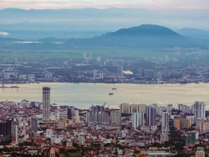
“We soon rose over the plain, and found ourselves on top of a hill called Bukit Indramuda,” according to Thomson, “covered with clove trees and plantain gardens, the property of some enterprising Chinese settlers. Here we could scan the whole province, from the Krean [River] to the Muda [River].” Thomson asked Oamut if he knew who owned the various plantations and was told that they all belonged to the “East India Company’s Chief Official”—a Scotsman named James Low. Captain Low (later Colonel Low) had been put in charge in 1826 as Superintendent of Lands of the Province Wellesley.[3]